

Powell’s Pals: W J McGee
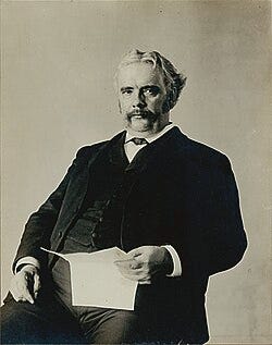
William John McGee was an American inventor, geologist, anthropologist and ethnologist. He was born and raised in Farley, Iowa. He always referred to himself as W J McGee (note: initials without periods).
Maj. W J McGee is reported to have been one of Maj. John Wesley Powell’s only pals who stayed true to Powell’s legacy, hence this Witness Post about him. While serving as a minor character in the larger Powell saga, he was highly regarded in Wallace Stegner’s book, Beyond the Hundreth Meridian.[1] W J McGee is often credited, along with Theodore Roosevelt and Gifford Pinchot, as the brains of the Conservative Movement in Washington, DC, at the turn of the 19th century.[3]
McGee Biography
While largely self-taught, W J McGee attended a rural one-room schoolhouse north of Farley, Iowa. He attended the schoolhouse classes during the four winter months for 10 years from about 1858 to 1867. The other eight months of the year, he was busy helping his family on the farm. McGee devoted his early years to reading and he developed a keen interest in the law. He also read abour conducting surveys. In his spare time he invented and patented several improvements on agricultural seed-planting tools and gardening implements. According to Wikipedia, he later turned his attention to geology.[2]
In 1877–1881, McGee executed a topographic and geological survey of 17,000 square miles (44,030 km2) in northeastern Iowa. He then undertook an examination of the loess of the Mississippi Valley, researched the great Quaternary lakes of Nevada and California. He extended his work and studied a recent fault movement in the middle Atlantic slope.[2]
Having proven himself as competent with his work on the surveys of the Mississippi Valley, McGee was appointed as a geologist for the United States Geological Survey (USGS) in 1881. In 1884, McGee compiled and authored the article Map of the United States exhibiting the present status of knowledge relating to the areal distribution of geologic groups for the USGS Fifth Annual Report.
McGee’s research focused mainly on glacial (Pleistocene) geology and the Atlantic Coastal Plain. At the time the map proved a milestone, as the first published geological map of the United States by the nascent USGS. It is generally referred to as the McGee Map. Its legend names and color-codes eleven geological groups, and it includes very fine detail of hydrology. It was the most up-to-date map of its era. As the title states, the map showed the “present status of knowledge.” In the West, the mapping surveys of Clarence R. King, Ferdinand V. Hayden, John Wesley Powell and George M. Wheeler were visible, but little else was mapped. Large sections of the western U.S. were left blank, which reflected how limited western exploration still was at the time. And filling in those blanks, perhaps not by accident, made the strong case for more congressional funding, which would have suited Hayden and Powell’s zeal for mapping just fine. That honest display of geological gaps is arguably its most interesting feature of the McGee Map.[2]
While with the USGS, in 1886 McGee travelled with Clarence Dutton (a fellow Powell’s Pal) to Charleston, South Carolina. Their mission was to study the recent earthquake disturbances in its vicinity.[4]
McGee was a founding member of the Geological Society of America and in 1890 was the first editor of The Geological Society of America Bulletin. Expanding on his wide interests and areas of expertise, McGee rose to become the ethnologist in charge of the Bureau of American Ethnology from 1893 to 1903. In 1895, he explored the Isla del Tiburón, Gulf of California, home of the Seri Indians. Also known as Comcaac people, the Seri Indians are an indigenous clan who live in Sonora, a state in Mexico. McGee had traveled to and studied native tribes in Peru, Mexico, and the U.S., primarily with the Sioux Nation of tribes. He also published reports on his findings.

In 1904 McGee was appointed chief of the department of anthropology that organized the “Anthropology Days” at the 1904 Summer Olympics / Louisiana Purchase Exposition. The events were significant because they occurred during the 1904 World’s Fair and the third official Olympic Games (in the modern era) which were held in St. Louis, MO. The timing of the Exposition was also intended to coincide with the 100th anniversary of the Louisiana Purchase (1803), which had added about 828,000 square miles, nearly doubled the size of the U.S. The total state, local and federal funding of the Exposition was $15 million (equivalent to ~$540 million in 2026). More than 60 foreign countries and 43 of the then 45 American states maintained exhibition spaces at the fair, and nearly 19.7 million people attended the pavilions and celebrations.
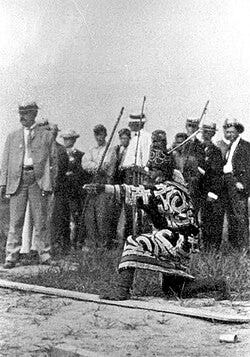
McGee and fellow organizer, James E. Sullivan, received public praise and recognition for ideation and execution of the Anthropology Days. Tying the events to the Olympic sports themes, McGee and Sullivan paid 100 indigenous men to compete in athletic competitions, such as “baseball throwing, shot put, running, broad jumping, weight lifting, pole climbing, archery and tugs-of-war.” The crowds were reported to be approximately ten thousand attendees.
In 1907 McGee was appointed a member of the Inland Waterways Commission by President Theodore Roosevelt.[3] The commission was created to investigate the transportation crisis that had recently affected the nation’s ability to move its produce and industrial production efficiently. The immediate crisis centered on insufficient railroad capacity developed by the private sector. Inland shipping had been under federal purview since 1824; however, it had been severely neglected and proved inadequate as a back-up to the railroads. The commission studied the Mississippi River basin, the Great Lakes, and hydroelectric power. Yet its results proved inconclusive and years later the commission was abandoned in favor of what became the Federal Power Commission.[3]
McGee’s other prominent public positions were: acting president of the American Association for the Advancement of Science (1897–1898); president of the American Anthropological Association (1902–1912); and president of the National Geographic Society (1904–1905).[3]
Personal Life
W J McGee was married to Anita Newcomb McGee in 1888.
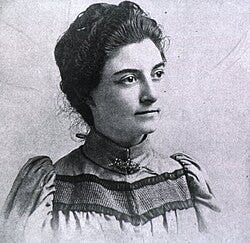
Dr. Newcomb McGee was a women’s rights activist and a renowned physician who worked with the military in our nation’s capital.
Anita Newcomb had attended a private school in DC, graduating in 1882. She then traveled for three years, attending courses Newnham College, Cambridge England, University of Geneva, Switzerland. She received her medical degree from Columbian College (present-day George Washington University) in 1892. Dr. Newcomb McGee won the first prize in dermatology and stood second in clinical medicine at her examination. She followed the prize with a special post-graduate course in gynecology at Johns Hopkins University.
Together with W J McGee, they raised three children.
W J McGee died of cancer in Washington, D.C., on September 4, 1912, at the age of 59. Anita Newcomb McGee died in 1940 at the age of 76.
Mount McGee, a 12,944’ peak in California, is named in his honor.
Published Works
McGee’s publications include the following:
- McGee, W J. “The Geology of the Head of Chesapeake Bay.” Seventh Annual Report of the United States Geological Survey to the Secretary of the Interior, 1885–1886, Government Printing Office, 1888, pp. 537–646.
- McGee, W J. “The Pleistocene History of Northeastern Iowa.” Eleventh Annual Report of the United States Geological Survey to the Secretary of the Interior, 1889–1890, part 1, Government Printing Office, 1891, pp. 189–577.
- McGee, W J. “The Siouan Indians: A Preliminary Sketch.” Fifteenth Annual Report of the Bureau of Ethnology to the Secretary of the Smithsonian Institution, 1893–1894, Government Printing Office, 1897, pp. 153–204.
- Muñiz, Manuel Antonio, and W J McGee. “Primitive Trephining in Peru.” Sixteenth Annual Report of the Bureau of American Ethnology to the Secretary of the Smithsonian Institution, 1894–1895, Government Printing Office, 1897, pp. 3–72.
- McGee, W J. “The Seri Indians.” Seventeenth Annual Report of the Bureau of American Ethnology to the Secretary of the Smithsonian Institution, 1895–1896, part 1, Government Printing Office, 1898, pp. 1–128, 129*–344*.
- McGee, W J. “Primitive Numbers.” Nineteenth Annual Report of the Bureau of American Ethnology to the Secretary of the Smithsonian Institution, 1897–1898, part 2, Government Printing Office, 1900, pp. 821–851.
- McGee, W J. Soil Erosion. Government Printing Office, 1911. US Department of Agriculture, Bureau of Soils Bulletin 71.
- McGee, W J. Wells and Subsoil Water. Government Printing Office, 1913. US Department of Agriculture, Bureau of Soils Bulletin 92.
References:
[1] Stegner, Wallace, Beyond the Hundredth Meridian, Penguin Books, New York, 1954.
[2] The relevant lifespan of the map was short. It was soon superseded by Charles Hitchcock’s 1886 map, which added more geological detail for the western states.
[3] https://en.wikipedia.org/wiki/William_John_McGee
[4] W J McGee was one of the men with whom John Wesley Powell found some of his strongest kinship, according to Wallace Stegner. The exploration of the relationship is outlined and discussed in another Powell’s Pals post on W J McGee and eight other scientists and explorers who were active during the Powell era.

