
The Building of the Pacific Coast Highway
From Arch Cape to Manzanita, Oregon
 Wesley Andrews
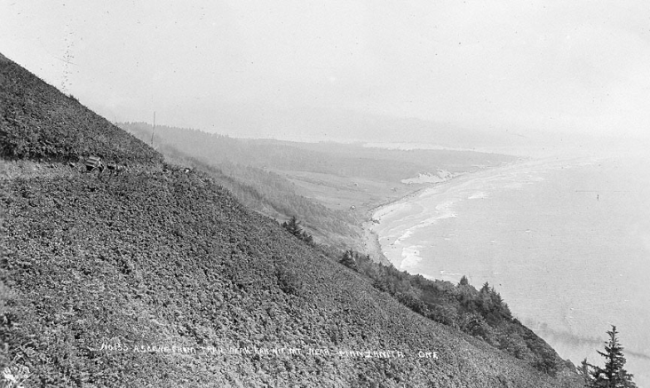
The panoramic view on the above is looking south along the Oregon coastline. The picture was photographed in 1915 from the steep slopes of Neah-kah-nie Mountain by Wesley Andrews, a producer of scenic view postcards. This is one of the treacherous trails that took travelers on foot over the mountain, connecting the beach trails from Arch Cape on the north with the beach visible in the distance. The trails had been in use for centuries by native Clatsop, Chinook, and Tillamook Indians and their neighbors.
For coastal Indians, travel until the early 1800’s was either on foot or by canoe. Canoes were suitable for major rivers and tidal estuaries, such as that of the Nehalem River, visible in the distance in this photograph. However, sea-going canoes were not common along the Oregon Coast, with its crashing surf, high winds, and strong and often erratic tides and currents. South from the Columbia River, the beach was paralleled by a series of dunes, lakes, and connecting sluggish streams, and travel on foot or by canoe was possible as far as present-day Seaside. From there, travelers had to climb on foot over densely-timbered Tillamook Head to reach Cannon Beach, where a few more miles of sand led to Arch Cape.

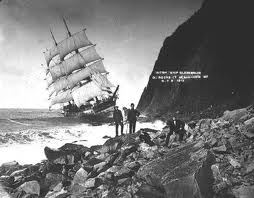
Old Road at Hug Point
South from Arch Cape, the trail led through timber and across wind-swept hillsides over Arch Cape, behind Cape Falcon, and finally along the treacherous face of Neah-kah-nie Mountain, “the terror of travelers,” as historical geographer Samuel Dicken put it. Composed of splintering shale, sandstone, and basalt, the 1,700-foot high headland has a western slope “as steep as the roof of a house and as it approaches the sea the slope breaks off in an almost vertical cliff, nearly 500 feet above the sea,” according to Dicken. The Indian foot trail, skirting the top of the cliff line to avoid climbing over even more loose rock, persisted well into the 20th century, gradually widened to permit horses and livestock to use the route. By 1915, it was possible to bring a horse and buggy over part of the route, as depicted in the photographs above and below.


The Oregon road builders had promised to make the area passable via automobiles to expand the home sites along the Oregon coast. The legislators and highway department were intent on completing an Oregon coastal highway in the 1920’s and 1930’s; however, they found Neah-kah-nie Mountain to be among their most formidable obstacles to the completion of their vision.

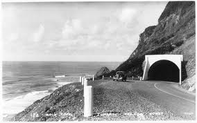
The coastal river mouths demanded the construction of a succession of immense bridges, a project that was completed in 1936. However, the coastal highway between Seaside and the Nehalem River still looped inland some dozen miles to the east around Onion Peak, thwarted by Neah-kah-nie Mountain. During the late 1930’s, a tunnel was blasted through the ridge of Arch Cape and high steel bridges were erected to span Arch Cape Creek, Short Sands Creek, and Necarney Creek. US Highway 101 was finally opened along the entire length of the Oregon coast in 1940. The photograph below was soon after the tunnel opened to through traffic.
 Boyer
Boyer
