
![]() Hikes: The Long Trail
Hikes: The Long Trail
Dates: May 15 – 30, 1974
Place: Mostly Vermont and the Green Mountains, but including parts of Northwestern Massachusetts.
May 15 – Departure
Dale Miquelle and I took off today from his house with Diana (Dale’s girlfriend) and Debbie. We had just had a nice day at the Miquelle’s house in Stoneham, near Boston, shopping for our supplies, mailing boxes and stuffing our faces with great food. We were preparing for an extended hike on “The Long Trail” in Vermont and the supplies list was longer than our packs could accommodate. We were able to mail one box of rations ahead to Rutland and another one to Montpelier, which we would drop down to from the trail to replenish our food supplies.
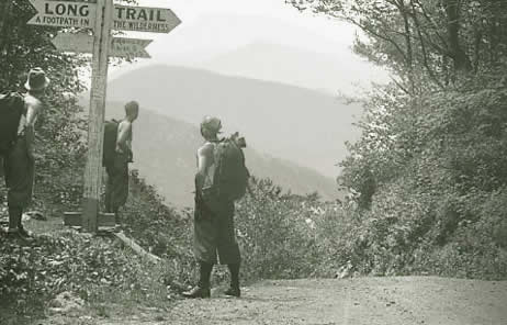
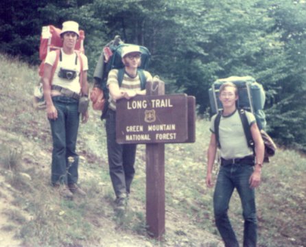
Dale had suggested the hike to me one afternoon after lacrosse. We hatched a plan, he bought the guide book and off we went. The Long Trail … is a 272 mile “footpath in the wilderness.” The Long Trail is also the Appalachian Trail for the beginning southern section, until the route hits Rutland,Vermont, where the Appalachian Trail heads off to the east and New Hampshire, while the Long Trail continues north to Montpelier and Canada. The Green Mountain Club, which started building the Long Trail in 1912, maintains the trail well. The Long Trail starts in Williamstown, MA and ends in North Troy, Vermont, which lies right at the Canadian Border.
We drove west to Williamstown and got mentally ready to hike, at least that is what we told ourselves. Both or us were seasoned hikers, but it had been a few years. We were in good shape after our lacrosse season at Yale, but running on manicured grass shape is not the same as hiking shape. Before long we arrived in Brockington, MA and had to depart from our two nice drivers. It was about 5:00 pm and we got underway after Dale’s “kiss and piss stop.” We waved good-bye and headed to the trail head on our way to Canada.

Crossing a cement foot bridge, we completed our first ascent. We hiked only about one half mile, but it was straight up in the blazing sun. Our packs felt like they were 100 pounds going up that incline. After taking off our wet shirts and putting in my contact lenses, we continued for about one half mile up the ridge. The trail crossed a swamp and went over some strange rocks until 7:30. We had hiked only a short distance in those two and a half hours, but it felt like it had been all day. We pitched camp, cooked a disastrous meal and got ready for bed. A storm brewed to the north and it was half way to us when the clouds parted and the sun suddenly broke on the horizon — it was spectacular! Little did I know that this would be one of the rare times we would see the sun setting over the horizon all trail long.
After dusk the rain came down in torrents and the downpour lasted for many hours. We tried to fry up the Bisquick to make pancakes for bread for the next day, but that cooking episode was the worst; as we scurried around the wet tent, Bisquick spilled all over everything. That night we had restless sleep, but at least we got some shut eye.
May 16
Up at 6:15 and on the trail, we had too little water to make a decent breakfast, so we decided to hike a bit and then eat. It was a cool, clear morning and we hiked about two solid hours before breaking out our stoves to cook. The traveling was good as we saw birds, butterflies and reptiles as well as lots of flowers. (I will save my lists for later in the journal.) After breakfast we traveled up through several forests of beach trees and lots of fir and beach shaded streams.
After hitting several beaver ponds (trees gnawed about a foot from the ground), we stopped for lunch, which tasted pretty bad: tuna fish, Spanish nuts, peanut butter and jelly, and Wiler’s to drink. Wow! After our daily constitution we were off again to travel up mountains, across valleys and through the muck! We hit some nice peaks too, so that made up for the sopping wet boots and sour humors. After soaking our feet in one stream, we rebooted and hiked the last three miles of the day on a trail that went straight down. It was a bummer, our shoulders and feet hurt terribly as we hit Vermont Route 9, a dumb road. That made it a 16 mile day.
That night we pitched camp and had a super dinner, which made up for all the trouble meals thus far. As we dined we saw four hikers zip by, and that was after seeing no one all day long. Very tired, we could barely hold a conversation with each other, much less the other hikers. We needed to rest our weary bones for the next day’s assault of the Long Trail. As we went to sleep that second night, it began to rain. The soft sound of the rain, however, blended in with the sound of a near-by brook, which lulled us quickly and deeply into slumber.
May 17
Thunderstorms woke us up at 2am, 5am and again at 7am, so it was “snorus interruptus!” I stayed in my sleeping bag until 7:30am praying for quiet. We packed our wet tent and left our nice camping spot to hit the trail going up…at least we thought the trail headed up. It turned out that we had headed off in the wrong direction. We didn’t realize our mistake until we double checked the guide book. After some cross words were spewed, we turned around and retraced our steps about a mile. Back down the stream and off to the main gravel road we went, enjoying again the view. As we regained our directions on the trail we were chased by some dogs from a near-by yard; next we saw that the rain was threatening again and the drizzle started; finally, our backs, legs and shoulders started to ache. Dale and I realized anew that we were NOT in hiking shape, that fact we knew for sure.
The water features (riffles, streams, brooks and rivers) were full of the recent rains. And Bolles Brook was gorgeous with the mist rising from it. Dale and I took the time to swap tales of youth and romance. (He had more stories on both counts.) We were deeply absorbed in our stories and I laughed a lot.
Our fun soon came to an end, however, when we realized that the trail we had followed, two miles nearly straight up hill, was once again the wrong trail! Cuss, cuss, cuss! And after that more cuss words. We walked back to Bolles Creek Park only to discover that we had been on a parallel trail that was not clearly marked. By this point we were mad and knew that losing those three plus hours of hiking would hurt our chances of staying on pace and getting both the food pick up as well as to Canada. Every day counted! We had to get our orienteering straight or this would be a frustrating, circuitous trip.

We were now back in business and determined not to leave a marker without spotting the next one. And when in doubt, we committed to stop, pull out our compass, and if all else fails, check the trail guidebook. We agreed to make it work. Along the way this day we also picked up some new-found speed and told more jokes. Dale and I were determined not to let the logistical set-backs-to-date impact the hike.
The trail was as pretty as it had ever been. Along this stretch we walked through the beach trees and into the evergreen forests. We were in the foothills of the Green Mountains. It was great! When we needed support, we took out our knives and went to whittling: a staff to support an ailing left knee came in handy. Lunch near the coldest, nicest spring we had seen to date, we were off into the woods again in no time. (We also started to learn how to handle the Bisquick, as it was much better today.) The springs and woods led to a great lean-to cabin in the area. Not much further along, we came to a ranger’s station and a lookout tower. We decided to make the ascent. From the top we got a good view of Glastonbury. The smell of the evergreens, the ferocity of the wind, and the threatening rain made for an exciting trip up that tower, especially since the first two flights of stairs were missing. We shimmied up the railing, taking extra care not to get hurt, as the wind was intense. I snapped a couple of pictures, but it was too windy and hazy to get any good shots.
We hiked through one of the best scented forests on the next hiking stretch: balsam fir or something like that, it smelled like those pillows you buy in the tourist traps: Scent of Vermont. There were even patches of snow, as we hiked up and down the ridges in this section, remnants of a long winter. The trail was pretty much up and down for the next six miles, with only a few vistas through the trees to the valleys below.
The day was long and we covered a lot of ground, but due to our early mistakes, we were only 11 miles further along the trail. Minor contribution to the total trip, as we had probably walked double those miles. Oh, well.
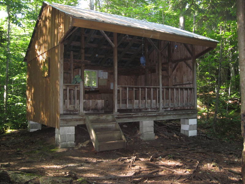
When we reached Kid Gore Shelter, there was a porcupine who had taken up residence there. Dale stalled and cornered the beast, while I took a picture. The campsite was really good, but the “night of the porcupine” that followed would not be soon forgotten. Dale had to get up five times in the night to shoo away the varmint(s), wood rats, porcupines and other critters. Those damn rodents kept getting into our packs and eating things. The one saving grace was that we had washed our clothes, particularly our socks, before it got dark. We heard from some other hikers that the porcupine are really looking for salt and they will eat salt stained sweaty clothes for the sodium chloride. Not much sleep that night, to say the least.
May 18
Not up until 7am today, and not on the trail for about 45 more minutes. It was so exhausted. Plus it was misty and foggy we took it as a sign to stay cozy. We couldn’t get up. Still hung over from fighting off the porcupines. When finally on the trail again, we summitted several nameless ridges before the fog clearly enough for us to see any distance of consequence. As the morning wore on, we made our was to South Adler Brook, where we had a weak breakfast before moving on. The many beaver ponds made great picture taking and good sight seeing in general. It seems like the outskirts of Walden Pond, really. Crossing more brooks and doing more climbing, we passed several fellow hikers traveling the opposite direction. There were families, dogs, teenagers, adults and even an old man, who wore a fish net shirt much like the one I had taken to wearing. We were pretty snobbish as through hikers. These were mere “day hikers.” When we reached Stratton Pond, though, we saw what they had come from and had a new respect for our fellow day trippers. Stratton was clear and scenic. We walked around Stratton and came next to Bourn Pond.
Bourn blew us away: it was spectacularly beautiful. If it had not been for some loud and obnoxious canoers on the pond, it would have been perfect. As it was Dale and I sat on the western shore and just admired how gorgeous the pond was. The blue sky, clear water and dark green trees were a spectacle to behold and to remember. We proceeded on a few more miles to complete our day: a 15 miler. Capping off the adventure, we boldly skinny-plunged into Bourn Creek, which was a refreshing wake-up before bed dip. We washed before dinner and retired early that night. We were praying that no porcupines (or bears) were in the area. Our blue tent was able to get a night to dry out, which was a good thing.

May 19
It was freezing, when Dale got up to pee at 5am this morning. We got up at 6am today, which was the time we had scheduled to wake up every morning. Finally on time! We had frost on the tent this morning, which meant that all of the drying overnight was for naught. Even our clothes, hung out to dry, were frost bitten. Dale’s suggestion of a morning dip was poorly received. On the trail by 6:30, we were absolutely frozen. Singing Bob Dillon songs and some Yale – SOB songs on the trail as a distraction, we had full sweats and gloves and hats on to keep from shivering. Before long, we spotted another porcupine. Luckily, though, there was no trouble as he let me photograph him up close and personal. That day we saw two porcupines, a scarlet tanager, ground squirrels, chipmunks and a few salamanders. It made for a good morning…that was until the aluminum frame of my backpack broke. Dale and I had learned awhile ago about duct tape and it was just the ticket to keep us in business. With a little rope in key spots and a lot of tape, we were back in business.
While we were having breakfast that morning, a bunch of “girl scouts” as we called them, came waltzing through the area. We had passed them the day before and were somewhat stunned that they were now passing us, the two college studs. The “Den Mother” said that he had gotten the kids up at 4:00am to eat and pack up so that they could be hitting the trail by 6am sharp. There were over a dozen of them. The leader said, “It is enough to kill you, right boys?” They were an unusual group and they had a strange feeling about them, so we were glad to pack quickly and pass them. We were haunted by them all day, feeling that if we stopped to soak our feet or birdwatch too long, they would be upon us.
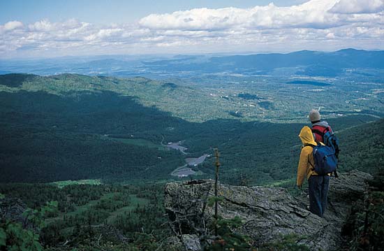
The views from Spruce Point were worth the extra few steps from the trail. The valley just below and the mountains in the distance were beautiful. Dale and I made decent time, traveling about 10 miles before lunch. Spotting a black-throated blue warbler was the highlight of my birdwatching that day. I got a clear image of him in my binoculars as he danced on a flowering tree. Finally we ascended and ascended and ascended, making it to the top of Bromley Mountain. It had a spectacular chair lift taking winter skiers to the top of the ski area. Atop the look out we saw everything for thousands of miles. We could have stayed up there all day! We were pushed, though, by three college girls, the type who give me weak knees. I was in love with one for sure, but one of her friends needed our help: she had an infected blister on her foot. Being a woman of independence, though, would take none of our assistance. Oh, well, to each her own.
Dejectedly we walked up the next mountain in the chain, arriving at Sykes Ridge for its beautiful views. Wow! Here we had pictures taken for posterity. We took the time to soak in the view, which was full of grace and omnipotence and grandeur. It was worth a thousand, zillion words. Our conclusions about society east and west were inconclusive. We “mozzied” on a few more miles into the woods, set up camp, and ate tons of rice, which proved a better meal than I had expected (… it is amazing how the hungrier you are the more tolerant you become of bad food). We went to bed on a full stomach for the first time all trip. Hooray!
May 20
Up at 6am again today. This was a glorious day. The sun was shining as brightly as ever aw we descended from Styles Peak into the adjacent valley and then up Peru Peak. The night was just as cold as the previous nights (low of about 28 degrees F), which left the still wet parts of the trail with crusts of ice on them. They remained frozen until the sun hit them later in the day. The crunch under our feet was part of the hiking sound of the season.
As Dale and I started to recalibrate, we both noticed that most of the aches and pains and blister problems were going away. Rambling with more ease now, we could hike up the mountains faster and glide down with fewer grimaces. It also helped that our packs were getting lighter by the day! We finished Division 3 of the trail guide and were off to Division 4 — the Big Foot still lay ahead of us.
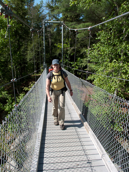
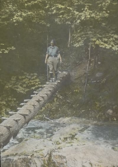
We thought that we might come upon Sasquatch when we heard some loud noises ahead. It turned out to be a French Canadian and his wife, who were hiking close to our heels. They were an attractive couple engrossed in conversation. In their mid-forties, the couple stayed within a few miles of us all morning, and like us they were efficient hikers. There were great paths and bridges in this district as we went over several well made wooden bridges, a suspension bridge, and many small toe bridges. The roads were in good shape too. After the suspension bridge, we are lunch. Our spot was down from the trail along Big Branch River. We found a great little spot in the full sun. The rushing water and sun made for a pleasurable meal and an even better post-meal siesta!
Emerald and Griffith Lakes were as pretty in the morning as was Lost Pond in the afternoon. (When we walked by Lost Post, Dale said, “This time the body of water was lost, not us!”) We sat by the waters edge in silence and reflected on the beauty of the water and the solitude of this place. A few nearby campers made some ruckus to halt our reverie, so we sped off to resume our hike. We knew we were on the White Rocks Mountain trail, but the signage was poor and we had to make sure we took the right one. We found what appeared to be the right trail, but it missed a spring and the summit, which we were supposed to reach. I had broken my trusty walking stick scurrying up one ridge, but found some new energy to burn off. It was better to walk fast and get tired than angrily search for a new pole.
We saw signage for Greenwall Shelter, which was our destination, so we walked in that direction. We were happy to see that the shelter was porcupine free. It had been a long day (17.5 miler), which was the longest trail distance we had covered to date. We also had peaked three mountains, which seemed a record for us as well. So it proved to be the longest and toughest hiking of our trip thus far. A camp fire in the fireplace make it feel like the real outdoors again! No other hikers shared our shelter, the food was good, the fire warm, and our sleeping bags cozy. Yeah!
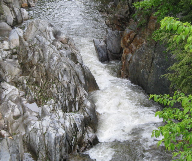 Clarendon Gorge
May 21
In our self congratulatory way, we slept in until 8am. Our fire and star gazing led us to some late night philosophy discussions. Upon rising the sky was overcast and remained so most of the day. After eating a stimulating grape nuts and honey cereal breakfast, we took off from Greenwall and headed to Wallingford Gulf Road (Vermont Route 140). [Why there is such an interest between Connecticut and Vermont for the name, Wallingford, I do not know. Must be a Green Mountain name of some historical claim.] As this juncture, we approached several houses to find out if East Wallingford were large enough to have a general store for our shopping needs. No one was at home and the cars along Route 140 were infrequent, so we took the hiking route to Button Hill. It was a long and arduous climb, but things went well aw we came upon Sunnyside Camp for an early lunch. After 4 Bisquick cakes each and lots of Wilers and chocolate, we lazily left for the trail to the Clarendon Gorge.
The route to the Gorge was covered with purple, white, and yellow violets, as well as lots of yellow and red columbines. This made me think of Dad as did the great brook trout streams we walked along yesterday. As expected the Gorge was closed due to a washed out suspension bridge. The closure took us on a two mile detour. On the way, following a series of yellow ribbons tied around random oak trees, we saw blue birds, orioles, apple orchards, and some neat old cabins. There was even a covered bridge, some beautiful barns, and a white church of particular note.
Dale and I trucked along Vermont Route 103 for a while, admiring everything but the road itself. We soon longed for that road again, as we hit a trail going up the side of the hill. We ascended a mucky, horse-shitty trail up to a ridge and then up to the summit (Beacon Hill). We hiked past some great open fields. They were grassy, rocky, and the perfect foreground for some pictures of the Vermont hills and mountains. The to the woods, where we found water and later a filed to pitch camp. Teriyaki rice, soup, pudding, and a fabulous view. Not bad at all! The day turned out to be pretty good, as despite the late start and long time hacking off along the trail, we covered over 13 miles. We also had spotted three deer, our first multi-deer sighting, which was cool. Dale cracked me up with a joke about a kid with an umbilical cord and I laughed until I cried. The stream was babbling and the sky had zebra striped clouds followed by quilted patterns which were great to watch as they floated by. The sights and sounds soon put us to sleep.

May 22
The field we stayed on was even prettier in the morning than it had been last night. The sun, caught in the early haze, woke us up at 6am. We got up, cooked Bisquick cakes and were back on the trail by 7:30. The sky became even more hazy as the day moved on, but there was no sign of rain. We went by Cold River Road and were nearly attacked by the dogs in the near-by homes. If they had not been chained up to fences, it could have been ugly. We did not need that on top of some stomach trouble. Dale was feeling punk all day, not sure if he would throw up or not. He felt rotten all day.
We reached Cold River and it was trouble. Dale fell in (one foot – boot & sock soaked) and I slipped, (bruised the hell out of my left leg). Somehow, we toughened up, and kept going all the way to Governor Clement Shelter, which is really a nice stone shelter in a grass covered clearing. We waited here before our great ascent to Killington Peak. The long and difficult climb was even more challenging because Dale felt so terrible. We stopped at all of the shelters along the route, taking rest breaks, having lunch and trying to settle Dale’s stomach. The last two miles or so I think Dale was too dazed to feel anything. The haze got thicker as we climbed Killington, so there was not much of a view from the top. We couldn’t see anything really, visibility was about 200 yards, if that.
We stayed the night in the shelter, Pico Camp, and were joined by two brothers, Mike and Owen. They were on a four day trek together, dropped off and picked up by girlfriends (sounded familiar). The spaghetti dinner was pretty good that night, though Dale Miquelle did not participate. Oh, well. Hoping things are better tomorrow. We had sights on hitting Sherburn Pass and then Rutland. We have a lot of shopping to get done, whenever we arrive in town. I was secretly hoping that there was a store near the trail, to save us from having to go into the heart of town.
May 23 – The Wizz Kids
We soon began to call ourselves THE WIZZ KIDS, more for our toughness and agility than our peeing prowess. So the Wizz Kids staying in bed until 8am today because it was foggy, rainy and generally miserable outside the shelter. Our cabin mates were kind enough to off us breakfast, which included coffee and cookies (the luxury of a four day trip with fresh rations). Dale ate a bit this morning, which was a good sign. He did not complain, but he still looked a little green to me. Mike and Owen had been more than generous to both of us and we own them a lot for a successful day. After breakfast some visitors came by the cabin to stop in from the rain, which was coming down steadily. Two of the hikers were from Worchester, Mass and they had hiked from the Mass line the same day we started in Williamstown. We just came upon each other today, which seemed pretty amazing. The could not have been more than a few miles from us the entire trip to date. After packing we headed down the trail to Long Trail Lodge and Sherburn. The four of us, Mike, Owen, Dale and I, made ready our packs and headed down the ridge in the rain. The guys from Worchester started after us and passed us at the next tree blaze, as Dale was still feeling punk. We did not see them again, so they were pretty strong hikers.
The trip this morning was pretty good, as the rain let up a bit and we made it down in fairly dry conditions in about one and one half hours. The Lodge was locked, but we found an attendant who gave us two letters and our package, which we had mailed to ourselves. Everything was in tact, which was comforting. The store was not near the trail, so we were fortunate that Mike and Owen were there. They gave us a lift into Rutland for phone calls and shopping. They really saved us, as it would have put a major dent in our mileage that day. We shopped at Finast, got lots of weird stares from the old ladies, and we made calls home. Dale called Diane and his father, Claude, while I called my Dad at work. He was in good spirits and happy to hear from me. He promised to give Mom and Charlie and Mary a full report. When we finished calls and shopping, Owen and Mike agreed to split a pizza with us, which Dale ate with gusto. We read what was happening in the world in the Rutland Times and our new best friends gave us a lift in their 1963 green Volkswagen bug. Their girlfriends had left it at the Rutland Lodge for them and they agreed to drop us back off at the Lodge. From the Lodge we said our good-byes and packed up all our gear.
Taking off again in the heavy rain, we hiked up the Long Trail to the Tucker-Johnson Shelter, where we stopped and stayed for the night. We arrived at 3:45, but were too wet and tired to push on further. Tomorrow will have to be a better mileage day, or else! Our dinner was bland, but filling enough to stave off hunger. My belt was taken in a few notches, so I knew my calorie consumption was less than my daily exertion. We watched as the fog rolled in extra thickly and the temperature dropped. It was really cold. We wished we had down booties or something like foot warmers to keep the bitter cold at bay. I was praying for no porcupines and better weather tomorrow. Dale read from his book, Tale of Taoism, while I read A Separate Reality. We had a brief discussion about God and Reality and decided that we could decide nothing definitive. Oh, well, what can I say? It is too dreary to thing deep thoughts right now. Better await a brighter day.
May 24
Today we start an unedited and unpublishable chapter in the adventures of the Wizz Kids. In our last episode, you may remember, they had a hard day, falling into the hands of roughians who kidnapped our heroes and took them to Rutland in a stolen car. Today they were once again on the trail and set for outdoor fun and hyperbolic adventure. The sun shone brightly in the faces of our heroes as they awoke, but the dark mist of misfortune was soon to overtake them. After leaving the confines of the Tucker-Johnson Shelter, we headed off into the Long Trail and we came across what appeared to be a conclave of salamanders. They were a firey red/orange in the muck beside the trail. These baby prehistoric reptiles grew monstrously large and surrounded the Kids, forcing them to hand over all of their Kool-Aid or else!
Thinking quickly, Dale pulled out his vorpal sword (in the Jabberwocky of life) and slew the beasts, one, two, one, two and through and threw he slay them. All of a sudden they were at Rolston Rest and eating breakfast, after the magic Bandersnatch had saved them from the jaws of destruction. Upon leaving the Rest, our heroes spilled some granola on the trail as a treat for the brown and black birds near-by! A huge Blackburnian Warbler swooped down to pick up dead trees for its nest and frightened the ground gremlins who were gathering there. Noyes Pond and Chittenden Reservoir were the two voluminous bodies of water that surrounded the Kids next, but the water was not nearly as frightening as the sheets and sheets of reain that assaulted them for the next 8 or 9 hours straight. The rains were torrential and almost washed our Kids off the sides of the cliffs and steep mountain slopes. No matter how much slogging they did, the water was still coming after them. Their trail guide was useless for about six miles as they trudged by beast and foe who cowered on the left and right of the mudluscious path. None would attack the Kids because of the horrendous downpour. Pole cats, snakes in the grass, saber-toothed tigers, Kodiak bears from across the globe — you name it, they were there to watch our heroes fall into oblivion so that they could eat the scraps.
Suddenly there was a 60 minute time out for lunch, and all of the characters retreated to their respective lairs to eat. Dale ate three tons of horse manure to whet his appetite, while Hoop watched in amazement. You see, while Hoop was formerly known by family members as the human garbage can, was being replaced and dethroned by Dale ” the pit” Miquelle. Hoop was thrown to the side, another also ate in the world of eating. Oh, well. Hoop still managed to consume his share of the grub: three legs of lamb, five chickens, and ten gallons of ice cream, and that was for hors d’hourvres.
After spilling their raisins into the mud and not having the eyesight to dig them back out, the Kids trudged on into the wet and cold. The water beast brought his army against our heroes and they attacked with fuller vengeance in hope of vanquishing them before the next TV commercial. Hours and hours of rain drenched them with no let up in sight. Their boots had been weighed down with five tons of mud which was slathered on the trail by the mineral goddess, who slipped in her omnipresent fashion between and among the mud puddles. Oh well. The Kids were tough and they knew they could take the punishment because as the saying goes, “You can’t get this back home!” Rattlesnakes, mountain lions, bears and wolves can’t stop the Kids (like Jeremiah Johnson). And neither can rain or mud or mineral powers.
After rolling down a flood and dagger booby-trapped logging road, the Kids came upon the Sunrise Shelter, inhabited by a German army sergeant and his hunchbacked mongrel dog. The dog had been beaten to submission too many times and he was a growling cur. (The man’s name was Matt and his dog, Clark.) The German sergeant then called out the troops, first there were the food spoiling demons, who spilled their dinner and ruined the Kids pudding. Secondly were the thousands and thousands of other campers who trudged into the campsite. The got down on all fours and crawled around till late at night. Finally the Kids got to sleep, but it was not easy. The morning, as it does after a late night, came early, along with its supply of wet socks and cloth weariness. The air was heavy as the Kids began to contemplate their next chapter. Another episode awaited them!

May 25 “In Search of El Dinkus Maximus” … the eternal quest.
Woke up this morning at 6am, but were thinking too much about shoving on those wet socks and heavy boots, stinky clothes and sopping hats. We lay in bed till the sun rose. The sky was clear at 6 and overcast again at 8. We took off and headed up, straight up Horrid Cliffs and rested there to eat breakfast. Our pattern of hiking before breakfast was slowly becoming the rule and we liked the habit. The view this morning was worth the climb. While we ate, we watched ravens as they chased each other in a string of flight preceding the darkening clouds. We ascended three steep peaks in a row (White Rocks Mountain, Lookoff Mountain, and Horrid Mountain). Then we ascended Romance Mountain and descended to Romance Gap. Even if it had been sunny, that would be one of the last places I would ever go to for ROMANCE!
Afterwards we descended gradually to Sucker Pond Shelter, where our trip quickly degenerated, if you can believe that it got worse. A hiker from Rhode Island (an oceanographer, he said) told us of his exploits, gave us some ham and cheese sandwiches, and then left. We lollygagged around for about an hour, thinking it was going to rain, and fell asleep in our sleeping bags. We were rudely awakened by the dinkus maximus to date: a 16 year old, wise ass, know-it-all, wearing a red ball cap. He wouldn’t stop talking. Not sure what he was talking about or why he felt he could wake us, we decided we could continue our siesta for a few minutes. We awoke and started talking to another man and his son. Finally at 4pm we left the shelter for some more peaks and ridges before stopping at Pleiad Shelter. We got slightly disoriented around some of the ski trails, but has a good time passing dinkus maximus and the other hikers along the way. (Dale said that he would rename any companions of dinkus maximus as the butt-fucks (BF’s). He was on the lookout.)
We reached camp and set up our tent. The Pleiad Shelter was already full by our arrival, but Dale felt the ground would be a relief from the bed boards, which were hard and creaky. I debated the choice or rocks in the back or boards in the butt, but let the issue die. It looked like more rain, which absorbed my attention. Would we ever get out gear dry again? It is supposed to be dry tomorrow, we heard a shelter mate say. We crossed our fingers, as we could use the relief. We had a good dinner and went to bed before dark.
May 26
My watch stopped during the night. When I was conscious and packing up, Dale told me it was already 10am. I couldn’t believe it. We had to scurry to leave. We did not want that much, just a dry day and some sun. Instead it was raining again and it continued to rain all day. The weatherman was wrong again! We passed our top contestant for the dinkus maximus award again. This time he was talking with two guys were in the running for BF’s. Off we hiked to Middlebury Gap. It was only one mile away and there we saw lots of cars from the weekend campers. Of to the next ridge, we went up and up again, not really stopping until we hit Boyce Shelter. We chose it for lunch. Honey, peanut butter, jelly, chocolate, raisins, Bisquick, and Wiler’s. Every bit of our lunch includes a dose of sugar, so we have to worry more about protein than sweets. After singing some songs to imitate the birds, we headed up Boyce Peak. We also scaled Battell Peak, named like the chapel at Yale, which made for two hard climbs in a row. It was cold at the top. We met a party of three nice men, one really distinguished balding guy with a Hitler-like mustache. Then as we went further on the trail, it started to hail. The cold clear balls pelted us for about 20 minutes. The were pea sized and covered the ground in a hurry, like snow. We took off at a faster clip to get to the next shelter. We came to a log lodge with a fire going, which was better than we hoped for.
Skylight Lodge had a gorgeous like in front and room for loads of people. It even had a loft for more folks to sleep. It was THE BEST place for us, and us alone, until three others joined us. We were martyrs and left the three for their own peace and serenity. As a bargaining chip they gave us some cheese strips and oranges. Seemed like a fair trade. We proceeded to hike to the Emily Proctor Shelter for the night. Dale and I were pleased to share our own company as it would have been embarrassing otherwise. We waged our gas war before dinner: all of the cheese and pudding can get pretty smelly before the digestion process is over. Post gas war, we sat down to a dinner of spaghetti, meatballs, soup, pudding, more cheese, oranges, and water. We had the ammo for tomorrow nights gas battle. Stuffed to the right level, we were ready for bed. That night we considered sleeping on the pine boughs, which had been left by some former shelter residents. They looked surprisingly comfortable, and they smelled very fragrant. We decided not to stay in the shelter when some unprepared scouts showed up.
I am not sure it was totally worth it, however, as we got awakened by some later arrivers, who clanged around till late. Losing the solitude of a cabin is a bummer. We were grateful that day that we had reached the 130.4 mile mark of our trip — the half-way point to Canada on the Long Trail. That mark was hit at the top of Breadloaf Mountain.
May 27
Not staying in Proctor Shelter turned out to be a better plan as the boy scouts were loud even snoring and they took up the entire space with their junk strewn about. The shelter had 9 campers in all, so we were glad to have the cozy tent as planned. We slept on some greens that we gathered on our own, which made for a soft pad. The boy scouts had one kid who was a “hot dog” and made an ass of himself. Dale said that he was a serious contender for the dinkus maximus award. He had hundreds of patches all over his back pack, from place across the country. He wore boy scout shorts, a red hat, and mosquito netting. One of the boys in their group was lost, so they walked all around shouting his name. As soon at they departed to the north, the fourth boy scout showed up from the south. We sent him on his way.
Dale and I got off to a listless start, feeling as if we had no energy at all. Our feet, hands, and heads felt like icicles and our motivation was low. Once again, no sun. Must be seasonal affective disorder or something. We truly realized that a hiker’s day depends on those yellow rays of hope. From the Proctor Shelter we went up several peaks. First we hit Mount Wilson, next Mt Roosevelt, then Mount Cleveland, and finally Mount Grant. These peaks would have seemed presidential, but for the rain and mist. There was no view and no sun in sight, so we climbed each peak, pissed on the marker and kept going. Nothing like marking our territory to claim our manhood.
Between Mounts Cleveland and Grant, we stopped at Cooley Glen Shelter for lunch. The lunch was good, raisin laced Bisquick, peanut butter, jelly, cheese, water, but it was almost too cold to really enjoy it. We started walking again slowly so that we would get too stiff. We walked for hours that afternoon, without much conversation, one foot in front of the other, wrapped in our own thoughts. The guide book called this stretch a level course, but it had some serious ups and downs, so it needs a serious re-write. We hit an “open area” with the first good vista in days. Dale and I sat for about half an hour and looked at the valley before us. The rocks were still wet, but we did not care. At least it wasn’t pouring. The mountains we had crossed were to the left and Mount Lincoln loomed ahead and to the right.
Going on, we hiked down to the road and over to the steep other side. It took about an hour to cross the “not smooth” lands to Battell Shelter at the foot of the Lincoln Mountain range. After scaring some porcupines away, we made camp and cooked dinner (undercooked hash brown potatoes, corn, pudding and Wiler’s). We made a fire and tried to dry our boots and socks, especially our socks, which had not been dry in days. Our feet had that blanched white wrinkly look that comes from too much time in the pool. We could use a break. Then we went to bed, loaded down with a pile of rocks to throw at the porkies, who would surely annoy us all night.
May 28
We awoke to rain again. It was 5am when Dale scurried about, but I stayed asleep until after 9am. At about 9:30 a group from Stowe High School pulled into Battell Shelter for breakfast. The leader, Mr McDonnell, appeared to be a nice, competent hiker. He was thorough, we could tell, but the kids were pretty young and they had packed things like candy (bags and bags of it) and coke bottles, and other junk food. They were only out for 4 days, but that is a lot of trash to lug around with you. It seemed weird that high schoolers seemed so young. After all, Dale and I aren’t that old at this point, but we sure seemed older than these guys. I had breakfast in bed and waited for the fog to clear. We picked up our books and read for a moment. It was raining a bit as we headed out again. The sky remained threatening until about 2pm, when the sun finally broke through. It was so good to be warm again!
Three guys passed us and went on to the chair lift at Castlerock, which was left open in the off season for the convenience of hikers. We decided to wait out the day at Battell Shelter and get up early to catch our last peaks. We read books, strolled around, sat on the roof, sang songs and had an excellent time. We even has a discussion about Gil Timm, our Yale friend, and Carlos Castaneda’s books on the Yaqui Way of Knowledge. As it started to get dark, we hurriedly washed the dishes and jumped atop the shelter roof to catch a glimpse of sunset. It was just sensational. For part of our time up there the rouge disk was casting a great white beam on Lake Champlain in the distance. The spectacle will not easily be forgotten. At this same time there was a mouse, a rabbit, and a porcupine who were running around the camp site. It was hard to know where to look next.

Just then we heard what seemed to be the sounds of two or three people singing on the trail. The voices kept coming closer and closer. When the songsters arrived in camp it turned out to be one guy, Willie Berliner. He is a Yale classmate, also a sophomore. His sister is in Morse with me and his dad teaches at Yale Medical School. Coincidences never cease.
Willie had started his hike on May 16th, the day after us, and he hiked solo. I could not imagine hiking this trip alone. As an Outward Bound and NOLS educated hiker, though, Willie was extraordinarily comfortable by himself. He was also great company. He told us how when he hiked, picture taking and journal writing were like dehydrated aspects of the trip. He feels that he would rather remember things as they happen, in a very existential approach to hiking. He said that too often one misses an experience because he or she is busy looking through a camera lens or having the energy flow through a pen to really live the event. Therefore, he has no camera and no journal. After thinking about it, I admitted that I liked those tools, as my memory is not as good as these tools. Photos and journals complement what has already been experienced.
Dale told of some stories of his Northwest Territory, Canada and Outward Bound experiences, some really frightening ones, and Willie told of his Long Trail trip thus far. He then went on to describe a trip he taken studying moose in Minnesota last summer, which was fascinating. It was a thoroughly enjoyable evening, topped off with warm tea, compliments of the Berliner private reserve stash. We all went to bed, prayed for good weather and got rocks ready for our attacks against the porkies.
May 29
It was raining at 5am and no sun in sight. Damn. We slept until 7:00 and left after a long chat and good breakfast with Willie. The climbs were just great today — easy and not too tiring. We climbed to the top of some good peaks: Mt. Abraham, Little Abe. and Lincoln Peak (all part of the Lincoln Mountains). All the peaks gave us good views, especially of the valleys, which were socked in with low clouds. The peaks popped above the clouds. The Sugarbush gondola popped above the clouds also. Off to Nancy Hawks Peak and Cutts Peak, we had no trouble scaling these peaks, which was nice. Hawks and Cutts had snow still remaining in lots of white patches along the way and although the views were limited, we did have some nice east and west horizon glimpses.
We zoomed over Mount Ellen, which is the third tallest mountain in the Green Mountains. At 4,135 it is pretty tall for New England. We hiked down the ski trails and went about 4 miles to the Glen Ellen Lodge. Here we shared lunch with the three guys from yesterday and we collected some wood for a fire. After stoking the cast iron, Montgomery Ward stove, Willie arrived and share some coffee with us. Then he was off for more hiking to round out his day. He was a good person to meet at this juncture of our trip. He put things into perspective for us. He is going all the way to Canadian Border (160.8 miles). We had counted our wounds and our blessings. On the wound scale, everything was held together with duck tape: the broken back pack, my disintegrating leather boots, the fierce calluses on our feet. We considered the alternatives and ultimately decided that it was time to head back home. We would not make it all the way to Canada with Willie this time. As a goal oriented duo, I was surprised by our decision, but not unhappy. Getting the post office to return the other box we had mailed ahead would be the easiest part of the decision. We did not struggle with our process; it felt like the right thing to do. We had been out in the wilderness for two full weeks and it had rained most of the last half. It was time for a break from this trip and a return to reality.
We cooked Bisquick, which we had taken to rename as JC’s Jabberwocky cakes, and we prepared the rest of dinner. We had enough fuel to make some taffy for dessert — gee, we are Wizz Kids after all. By then it was dark. Time to hit the hay for the last time on this trip. With some good luck, we would come to a road early and be able to hitchhike to Concord, NH tomorrow. We hoped to be back in Boston area in a few days.
May 30
The fog was thick when we awoke. It was 5am and the moisture was very heavy, when we checked out of the Glen Ellen Lodge. No picture taking, in a tip of the hat to Willie, just the memories. The route was pretty easy up to the next shelter, but after that the mud, roots, and rocks (the fateful MR&R) were unrelenting. We sloshed our way past several peaks and a ski lift before we made it to Stark’s Wall. From here is was straight down to the road, a few hundred vertical feet below. We made it to the road at a fast clip.

Hitchhiking was bad for about 30 minutes, as no one even slowed down as they zoomed by. They ignored our thumbs and seemed to veer ever too close to the road’s edge. Dale and I gave them a wide berth. As luck would have it, within the next 3 1/2 hours we were at Stoneham, Mass. An amazing ride from Vermont Route 17 to Vermont Route 100 and then to Vermont Route 89. That was a great stretch to get with one car, but not as great, nor as lucky as the ride from Peter and Anna from 89 all the way to Boston. Anna, it turns out, is Willie Berliner’s first cousin, which is totally bizarro to me. At Stoneham we stopped at Friendly’s for a bite, and then to took in a trip to the zoo! It was a lot of fun just sitting and standing for a change. Back at the Miquelle’s house, we weighed ourselves. Dale had lost 20 pounds, I had lost 25. Wow, that was so startling that we polished off a box of Toll House Chocolate Chip Cookies, drank a beer and lounged around the house. We went outside for a quick game of catch and throw with the lacrosse sticks before dinner.
Dale showed me a slide show of his pictures from the Northwest Territory, before we totally collapsed and went to bed…late…past 11:00pm, which was an eternity to us.
Thanks, Dale, for the trip and thanks, Willie, for the memories. I write this journal for you guys and for me. I won’t remember the trip if I don’t write about it. We will have to wait to do the northern section of the trail, which is supposed to be the prettiest, if not the driest part of the Long Trail.

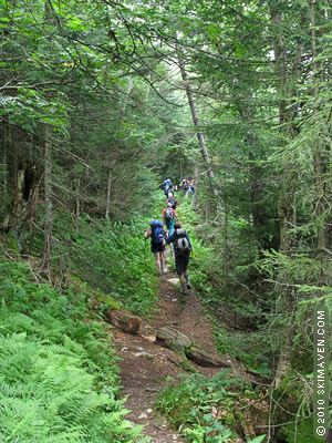
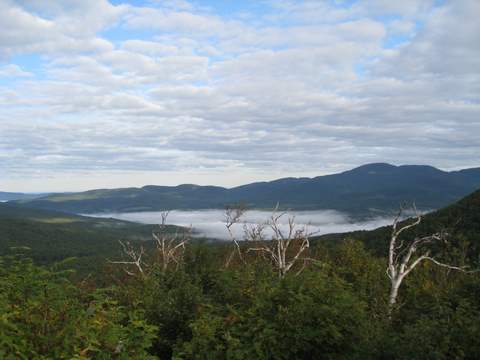
Post Script: In August, 2023, I went on an extended afternoon hike with my wife, Tracy, and our daughter, Margaret. We were staying in Stowe, VT, near the Mt. Mansfield State Park and wanted to stretch our legs. Why not go for a stroll on the Long Trail? Off we went to get our hearts pumping.

We headed up the trail toward Sterling Pond with high expectations. The trail went up and up without a break for about two miles and it gave us a run for our money. When we hit the ridge, the sight of Sterling Pond was just what we needed.


To the left of the Pond was a trail that led to the summer resting spot for the chair lift for Smuggler’s Notch. It seemed pretty rickety, but it offered a beautiful view of the land scape and pond below. We imagined it in the height of winter, covered in deep snow.
On the way down we spotted some salamanders and mushrooms, pictured here.


The Long Trail nearly 50 years later… this time it was just a walk for the afternoon.
